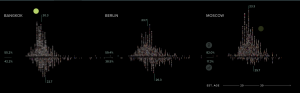
In the project, selfieCity, the primary digital humanity focus is visualization. It is a combination of selfies that have been taken by people from all different cultures and society’s all around the world. Each selfie shown is very different and unique; each person looks different and has a different way they take a selfie. For example, some people smile in their selfies and some make duck faces. The angle the photo is taken also differs from selfie to selfie. This project allows us to see up to 3200 photos within a short amount of time and to capture the idea that the norm of taking a selfie changes based on where you are from. A secondary approach in this project may include crowdsourcing because the viewer obtains a large source of important information within a short amount of time. It makes sense that Visualization is an efficient way to portray such subject matter because selfies taken from around the world is the best way to see the differences in society and culture. It is a more engaging way to understand than for one to explain through words.
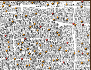
Visualization was also used in the second project I viewed, Map of Early Modern London. A secondary approach is also crowdsourcing because the project offered a location by category bar that allowed me to easily look up important locations on the map. I was able to obtain information quickly and efficiently about what London looked like through a visual field. The project gathered information from five encyclopedias and condensed it into a more fun style of learning. It offered me information on the people, the streets of the city, lifestyle, etc. The digital representation was helpful because the subject matter is about a city. People tend to be more engaged and understand material better if you have a visual sense of what the city looks like and have easy, quick access to the important material, instead of reading long, detailed articles.
Paige Whitney is a sophomore at Bucknell University. She is from Darien, CT. She is undeclared, but has interests in psychology, management, and economics.